CBSE Class 12 Geography Syllabus 2022-2023
Syllabus for CBSE Class 12 Geography 2022-2023 It is critical to begin early preparations for the CBSE Board Exam 2023 since it contains all of the main elements that are crucial from an examination standpoint. Students will become acquainted with the course structure and will have an understanding of the weightage of several Geography courses for the board exam. This will allow them to concentrate on the most critical sections. The full syllabus will assist them in planning the suitable subject for the board test so that they do not have to rush at the last minute. The details of the map work, as well as the question paper design, are also provided towards the end of the syllabus.
Skip to
CBSE Class 12 Geography Course Content 2022-2023
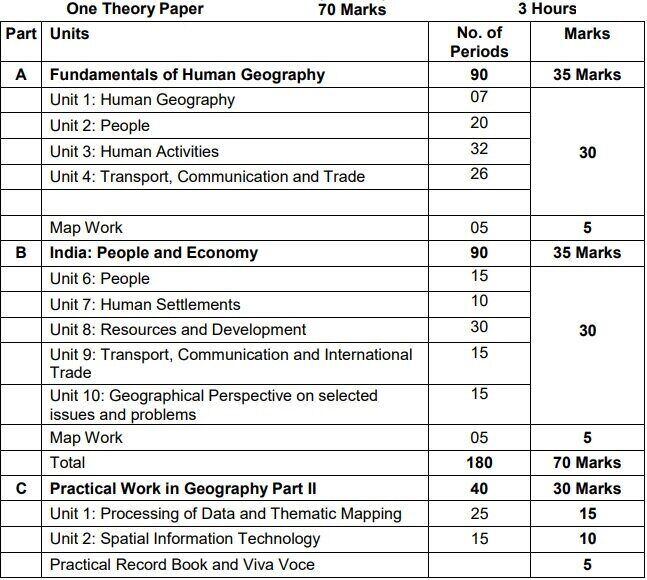
Part A: Fundamentals of Human Geography - 90 Periods
Unit 1: Human Geography: Nature and Scope 07 Periods
Unit 2: People - 20 Periods
The World Population- distribution, density and growth Population change - Components of population change, Demographic Transition Human development - concept; selected indicators, international comparisons
Unit 3: Human Activities - 32 Periods
Primary activities - concept and changing trends; gathering, pastoral, mining, subsistence agriculture, modern agriculture; people engaged in agricultural and allied activities - some examples from selected countries Secondary activities- concept; manufacturing: types - household, small scale, large scale; agro based and mineral based industries; Tertiary activities - concept; trade, transport and tourism; services; people engaged in tertiary activities Quaternary activities- concept; people engaged in quaternary activities - case study from selected countries.
Unit 4: Transport, Communication and Trade - 26 Periods
Land transport - roads, railways; transcontinental railways Water transport- inland waterways; major ocean routes Air transport- Intercontinental air routes Oil and gas pipelines Satellite communication and cyber space importance and usage for geographical information; use of GPS International trade- bases and changing patterns; ports as gateways of international trade; role of WTO in international trade
Map Work on identification of features based on 1-5 units on the outline Physical/Political map of World. - 05 Periods
Part B: India: People and Economy 90 Periods
Unit 6: People - 15 Periods
Population: distribution, density and growth; composition of population - linguistic, religious; sex, rural-urban and occupational-regional variations in growth of population
Unit 7: Human Settlements - 10 Periods
Rural settlements - types and distribution Urban settlements - types, distribution and functional classification
Unit 8: Resources and Development - 30 Periods
Land resources- general land use; agricultural land use; geographical conditions and distribution of major crops (Wheat, Rice, Tea, Coffee, Cotton, Jute, Sugarcane and Rubber); agricultural development and problems Water resources-availability and utilization irrigation, domestic, industrial and other uses; scarcity of water and conservation methods-rain water harvesting and watershed management Mineral and energy resources- distribution of metallic (Iron ore, Copper, Bauxite, Manganese); non-metallic (Mica, Salt) minerals; conventional (Coal, Petroleum, Natural gas and Hydroelectricity) and non-conventional energy sources (solar, wind, biogas) and conservation Planning in India- target group area planning (case study); idea of sustainable development (case study)
Unit 9: Transport, Communication and International Trade
Transport and communication-roads, railways, waterways and airways: oil and gas pipelines; Geographical information and communication net works International trade- changing pattern of India's foreign trade; sea ports and their hinterland and airports
Unit 10: Geographical Perspective on selected issues and problems - 15 Periods
Environmental pollution; urban-waste disposal Urbanization, rural-urban migration; problems of slums Land degradation
Map work on locating and labeling of features based on above units on outline map of India. (05 Periods) Part C: Practical Work in Geography Part II - 40 Periods
Unit 1: Processing of Data and Thematic Mapping - 25 PeriodsType and Sources of data:
Primary, Secondary and other sources Tabulating and processing of data; calculation of averages, measures of central tendency Representation of data- construction of diagrams: bars, circles and flowchart; thematic maps; construction of dot; choropleth and isopleths
Unit 2: Spatial Information Technology - 15 Periods
Introduction to GIS; hardware requirements and software modules; data formats; raster and vector data, data input, editing and topology building; data analysis; overlay and buffer.Prescribed Books: Fundamentals of Human Geography, Class XII, Published by NCERT India - People and Economy, Class XII, Published by NCERT Practical Work in Geography Part II, Class XII, Published by NCERT
Conclusion
The CBSE syllabus for class 12th geography covers a wide range of topics, including physical geography, human geography, and map work. Students will learn about the earth's landforms, climate, soils, natural vegetation, and wildlife.
FAQs
Q1: What are the main topics covered in the CBSE class 12th geography syllabus?
A: The main topics covered in the CBSE class 12th geography syllabus include physical geography, human geography, and map work. Students will learn about the earth's landforms, climate, soils, natural vegetation, and wildlife, as well as human aspects such as population, migration, cultural patterns, economic activities, and globalization.
Q2: What is the purpose of studying geography in class 12th?
A: Studying geography in class 12th helps students gain a better understanding of the world around them. It helps students develop critical thinking and analytical skills, and it prepares them for further education and careers in fields such as environmental science, urban planning, international relations, and more.
Q3: What is map work in the CBSE class 12th geography syllabus?
A: Map work is a practical aspect of the CBSE class 12th geography syllabus. It involves the interpretation and analysis of maps, including topographic maps, weather maps, and thematic maps. Students learn how to read and interpret data presented on maps, and how to use maps to gather information and solve problems related to geography.
Q4: How can students prepare for the CBSE class 12th geography exam?
A: Students can prepare for the CBSE class 12th geography exam by studying the syllabus thoroughly, practicing map work and data analysis, and solving sample papers and previous years' question papers. They can also use reference books and online resources to supplement their learning and gain a deeper understanding of the subject.
Download the full syllabus from the following link and check the details of map work as well:

MissionGyan Team
We aim to eradicate the education gap and serve equal and free education to all with the help of skilled and expert volunteers and teachers.